


The Capuchin Way - Bike - Stage 6
PO21-2 On the Trails of the Capuchins: From Montefortino to Castignano among Mountains and Historical Villages
Mean
-
 Bike
Bike
Itinerary duration
-
 1 day
1 day
Tipo di Bicicletta
-
 Mountain Bike
Kind of territory
-
 Hills
Hills
Difficulty
-
 Difficult
Descrizione
The cycle itinerary is a fascinating route connecting Montefortino to Castignano, crossing some of the most evocative landscapes in the Marche region. The route begins in Montefortino, located at an altitude of approximately 581 metres, and ends in Castignano, at an altitude of 450 metres.
This itinerary, about 59.5 km long, winds through a predominantly mountainous and hilly terrain, characterised by challenging climbs and descents that require good physical preparation. The total positive altitude difference is approximately 2462 metres, which makes the route particularly suitable for experienced cyclists looking for a challenge.
Along the route, areas of great natural and cultural interest are crossed. However, cyclists can enjoy breathtaking views of the Sibillini Mountains and the Marche countryside, passing through small villages and ancient paths rich in history.
The estimated time to complete the itinerary is about 4 hours for well-trained cyclists. However, the time may vary depending on stops to admire the views or to visit places of interest along the route.
Part of the Capuchin Way (link), this itinerary is not only a physical journey but also an opportunity to reconnect with nature and discover the rich cultural and spiritual heritage of the region. The landscapes traversed offer a unique experience, where the beauty of nature is interwoven with history and spirituality.
Characteristics of the route
Lenght: 58,9 Km
Difficulty1◇ Easy
Hard ◇5

Points of interest along this route
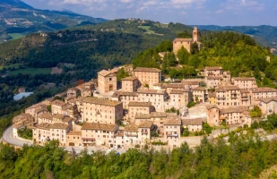
Montefortino
The town, perched on a hill, has a significant heritage of cultural assets, including the P...